Showing posts with label Raquettes. Show all posts

Wednesday, March 18, 2015

Tete de Bostan (2406 m)


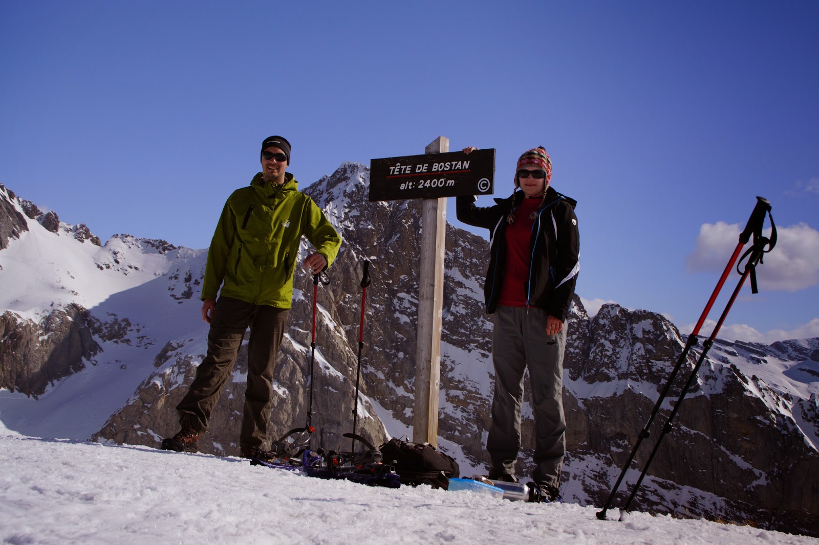
Our first big hike this season -Tete de Bostan. We're gaining elevations gradually, 2406 m is already pretty high up so I can't wait for the rest of the season to see if we are able to beat our record. I saw photos from Tete de Bostan on my friend's FB and immediately decided I wanna go there. I knew it would be a challenge with nearly 1400m of elevation gain but couldn't resist anyway. Especially after our previous hike that was not very satisfactory when it comes to length.


Before having challenged the mountain, as usual I checked the opinions and conditions on route. One guy wrote: "It sure is one long ridge". I seriously can't argue with that! This mountain has like 3 false summits! You think it's there, you can see your destination, you're approaching with the rest of your powers only to learn that it's not there and you have like another hundred of meters to cover. A bit annoying :) For example look at the photo below where I am pointing to what turned out not be our destination and Radek pointing to the real Tete de Bostan.


We had a very nice weather that day. The sun was frying us and we got some really nice tan despite having put factor 50 of sun block :) And the views were rewarding throughout almost all of the hike.


Final meters were tough to me but I was making a steady progress because I was curious of the vertigo-building line right before the summit (see photo below).


We were right on time on the top as soon after we did some photos the weather changed and became clouded. Going down was frustrating. We shared our route up with lots of ski tourers and every time I saw them I was envy they had skis and I didn't. I mean, I know I probably don't have enough skill to ski down such a slope but it would have made everything so much easier! I have no doubts that ski touring will become my thing soon! But for now - long and tedious way down on snowshoes.


Sunday, March 15, 2015

Pointe de Bellevue (2041 m)


I really longed for a proper hike and was very excited about the one we were supposed to have that day. But I also chickened out a bit and settled for a not-so-challenging route which turned out to be a mistake. I mean, don't get me wrong, the hike was very nice but I had a bit of a feeling of dissatisfaction afterwards - like I wanted more that day but the route had finished... Anyway, we will have a chance to have another one so nothing's lost.
But to the point - our destination: Pointe de Bellevue - which in translation would be Peak of Beautiful View. It really was, but I'll get to that later.
We started our hike on a very steep meadow where we gained elevation super quickly. It wasn't a real trail, we just crossed the field where convenient for us. We didn't intend it, we were following someone else's gpx track that had been named as the official route. Bummer.


What I liked most about this hike was the constant presence of Dents du Midi. Most of the hikes we do here are more in vicinity of Mont Blanc. It's funny because every time I see Mont Blanc it tempts me to climb it some day. And when I was close to Dents du Midi it made me wanna hike them again since last time we were there we didn't have perfect conditions and it's this kind of mountain that you wanna see crystal clear all around you.
Back to Pointe de Bellevue - our route there was pretty easy and as soon as we left the grassy steep hill behind us, we equipped our snowshoes and continue along the slopes straight to the top. From there we had a really nice view around the valleys and to the surrounding tops. Although there was no sunshine, we could see as far as the Italian mountains.


It was pretty windy up there so after a couple of photo shots we continued our hike down the marked trail to the ski station, where we took the already known off track path. It was a nice walk but made me want a bit more.


Stats: Max altitude: 2041m; elevation gain: 800m; Length: 7.3 km; Duration: 3h 40min

Sunday, March 8, 2015

Plateau des Glières (1782 m) on snowshoes

At last! Clear blue skies, lots of sun, lots of snow and mountains. Liking it... No... Loving it :)
We set off for our second hike this year and it was a blast this time. We headed for Chalets des Auges and in order to reach them we needed to traverse the Plateau des Glières which opened a magnificent view over the Aravis mountains. Simply stunning, but we'll get there in a moment.


We set off from Col des Glieres where nordic skiers have their earth paradise. It looked really awesome with all the routes prepared for amateurs of winter fun. We never got into nordic skiing but who knows what will happen in the future!


The route was pretty straightforward (I always choose easy ones when we go with our son on the back). Except for a pretty steep section in the woods, it was all nice and neat. When we reached the plateau the views took our breath away. It was fun to have a look at the chain and to recognize the mountains we had already hiked.


Once on the plateau, we did a short walk to Chalets des Auges (1782 m), took a few other photos and went back to the car by the same route. It really was a very nice family hike for us.


Stats: Length: 7 km; Elevation gain: 400m; Duration: 3h

Saturday, February 28, 2015

Let the hiking season begin: Orsière (1750m)


I have to admit it - I got a bit tired of skiing. Maybe not that much of the activity itself but rather the side effect that we didn't spend enough family time together. So this week we are taking a break from skiing, not from mountains though!
To inaugurate the hiking season I chose something easy, in any case, when we have a toddler on our back we're not able to climb hell rocks and devil pits. Pointe d'Orsière seemed like a good choise - with no technical difficulty and low altitudes. And it was, with one 'but'.


The weather was a bit unfortunate. We drove there in full sunshine and took off all the layers in our car. But as we entered the car park it got gloomy and with every minute it was only worse. Throughout the whole day we saw the sun only a couple of times on our way back.


Although the route was very easy, we did struggle with ourselves. When you look at this outing from the perspective of our past hiking routes, this should have been like a walk in a park. But it really wasn't! It's sad how fast we lose the stamina when we stop doing sports. On top of that, our son is really heavy now so the 550 m of elevation gain we did is the maximum for hikes with him.


The whole trip made us so tired that 100 m before the summit we even considered turning back. In the end we turned down that thought and continue to the top following ski tourers' trails. We spent only a couple of seconds at the top and descended by crossing the snowfields in the fresh powder snow. It's always the best fun, as it literally lifts you when you rush down the slope in snowshoes. By no means the best part of the day!


Stats: max altitude: 1750m; elevation gain: 568 m; length: 12 km; duration: 4h 10 min